


- Follow GET OUT ADVENTURES on WordPress.com
Categories
-
Recent Posts
- Awe and Adventure in Aoraki’s Alpine Arena
- An Odyssey Across the American West
- Day Hikes from Queenstown Like a Bos
- Land of the Long White Cloud
- California Dreaming
- Packrafting the Charismatic Colo River, NSW
- 100 Hours in New Zealand
- Bushwhacked in the Budawangs
- Reverse Mt Solitary Traverse (in a day)
- Pilgrims in Tasmania’s Holy Land: Walls of Jerusalem National Park
- Expedition X – Midwinter in Kosciuszko NP
- Mt Solitary’s Magnetism Draws Us Back
- Distance Makes the Heart Grow Fonder: 55km over 2 Days in Budawang NP
- Flashback: 5, 4, 3, 2, 1 … Bungeeeee
- Flying High – Scenes from the Air
- Mount Solitary Reunion Trek (Blue Mountains)
- Above the clouds – Barrington Tops
- A Fragment of Solitude
- The Stromlo Effect — MTBing in Canberra
- Hang Gliding in Rio de Janeiro
- Kayaking in Sydney Harbour
- Flashback: Downhill MTB at Thredbo
- SUPing at Fairy Bower (Manly)
- Stairway To Heaven (In The Budawangs)
- Flashback to Northern Thailand (Pai) Trek 2003
- Surfing at Stanwell Park Beach
- Mountain Biking at Manly Dam
- Cycling Ku-Ring-Gai Chase, Whale and Palm Beach
- The Dingoes are Howling
- Mount Solitary Traverse
- Stanwell Park Cycle Journey
- Blue Mountains Canyoning
- McCarrs Creek — Go North!
- The Four Gorges — Ups and Downs
- Southern Highlands — Exploring the Backcountry
- Thredbo — Mini Mountains (Proposed Trip)
Pages
Contact
danielbos1@gmail.com
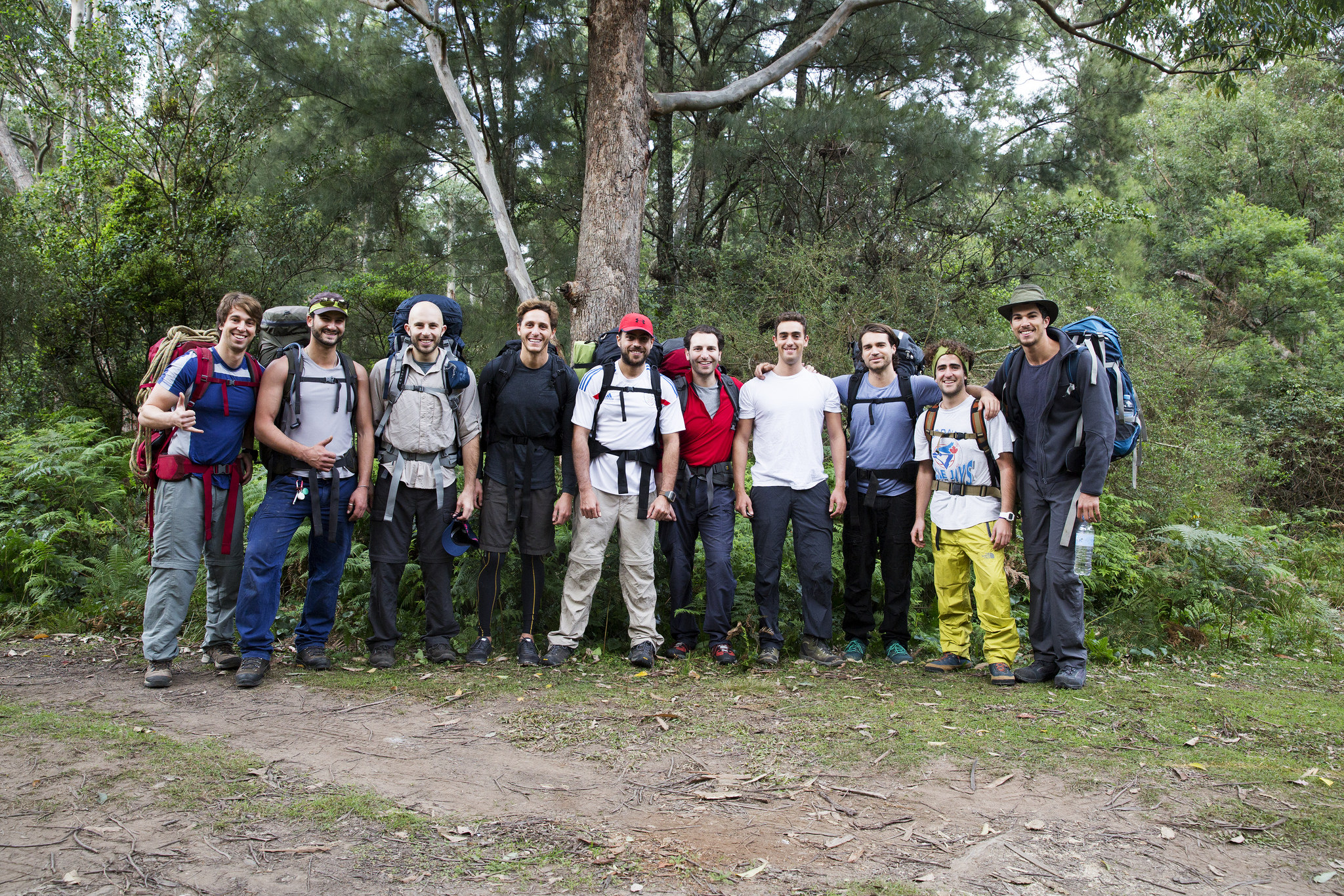
Stairway To Heaven (In The Budawangs)
Tackle a few more short steep climbs with the assistance of chains and suddenly Monolith Valley opens its heart to us. The track leads directly to an isolated monolith the size of a small building. It beckons. We climb. It’s top is flat, perfect for a lunch stop.
Recharged after lunch, we part with packs and explore the valley’s complex array of intertwining tracks and false leads. It’s easy to get lost here and careful navigation is vital. We push on through thick sharp shrubbery hoping to reach Seven Gods Pinnacles but we’re disoriented and think it’s much further than it is. Still, we are lucky to stumble upon an immense sandstone arch, which marks our turnaround point. But the valley doesn’t release us that easily, not before Franky believes he sees a Funnel Web, Jason subsequently endures a case of arachnophobia and Blitz and Bos slip into hidden waist-deep pools of water.
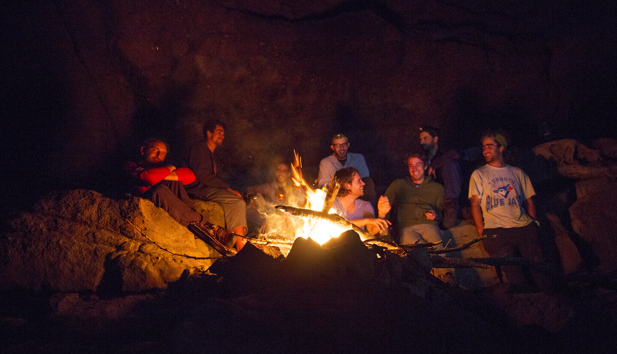
The cavernous cliffs of Cooyoyo – well spotted by Shaun – become our home for the evening. The overhang is a frozen stone wave and we sit in its embrace. The ground is layered and tiered creating a natural amphitheatre that positions us comfortably around the campfire.
Sunday, 25 May 2014
We enter the Tunnel’s mouth. Swallowed, we move through the slender belly of the mountain before it spits us out the other side.
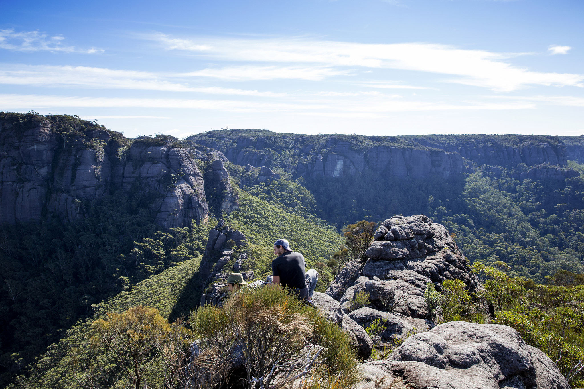
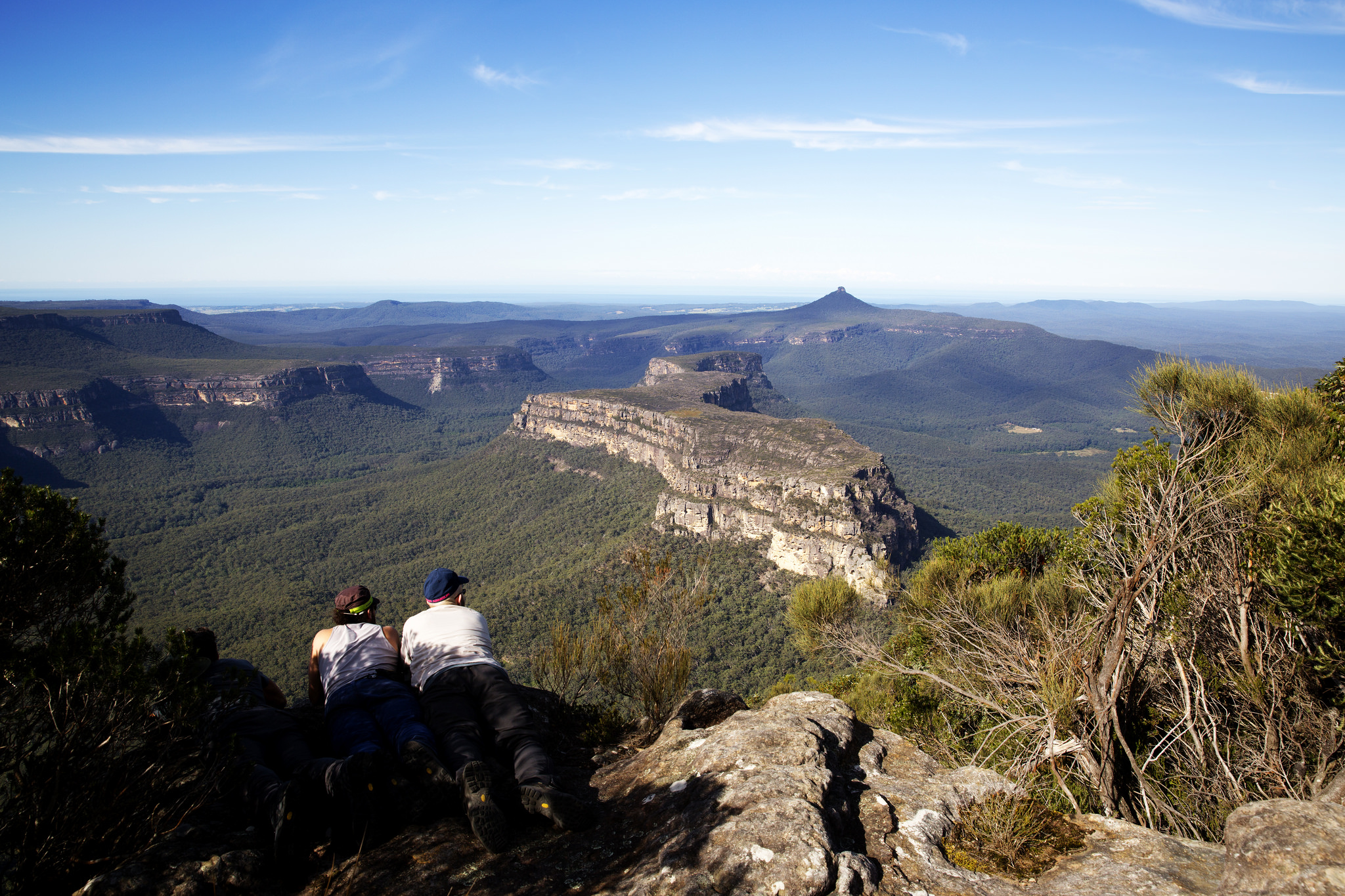
Liberated of packs, our steps are longer, our pace swifter. A few hundred metres past the Tunnel exit, the climb begins in earnest. We clamber and scramble some more until we confront a steep, almost sheer, section. It requires judicious use of handholds and footholds; Lee scales it first and drops a rope. Jason is keen and goes next. It’s challenging but we progress! Onwards and upwards. We reach the tadpole tail and those summiting first say to those below: “don’t look out until you’re up here” their voices full of excitement. Natural beauty abounds – Mt Owen and Mt Nibelung opposite, Clyde valley and the Yadboro basin hundreds of metres below. It’s timeless, serene, mind blowing. We fall into another moment of quiet.
With time a constraint we start to descend but some of the team encourage us to keep going. And so, our ascent continues. We climb a series of large stone masses and steep rocks using ropes and other natural elements that give us purchase. The tadpole’s tail guides us towards the Castle’s peak until finally we are atop the Castle proper. The stunning vista of the Castle plateau opens up before our eyes and some distance ahead we reach the best panoramas of all – the striking walls of Byangee basking in the sun, pointy Pigeon House, the double terraced cliffs of Mt Talaterang to the east and finally the ocean, such is the extent of the visibility today.
This entry was posted in Bushwalking and tagged Budawangs, bushwalking, the Castle. Bookmark the permalink.

Really great read and thanks for the share. I live in Canberra and plan to head there once the weather gets warmer. I’ve had a lot of problems finding a descent map to guide my trek through this area to reach the castle. Have you come across any maps? Also how well marked is the path and are the ropes to reach the submit included?
Thanks
Hamed
Hi Hamed,
Thanks for your message. If you want to head into the Budawangs and climb the Castle then you’ll need at least this topographical map – LPI Corang 8927-3N 1:25000. I strongly recommend you study the maps beforehand and take them with you. Be sure to follow regular bushwalking risk mitigation including telling people where you are going, taking a PLB and so on.
In terms of markings, this is an off-track walk and so some reasonable navigation skills are required, however, as more people do this walk, they are leaving signs (e.g. cairns and markings) to give directions but I would not want to rely entirely on these. If you head into the Monolith Valley then you really need to be cautious as there are lots of false leads and it can be a bit of a maze.
In terms of ropes to get to the top of the Castle – yes, there are plenty that are already there, which have been left behind by other hikers. I’d keep one hand on the Rock and one hand on the rope… You just don’t know the quality of the ropes and whether they have degraded over time.
There is one section which did not have ropes when I did it but we had our own and we used them. However, I recently did the walk again and I’m not sure how but we must have taken a different route and avoided this part, which I found to be the hardest part requiring a head for heights.
Good luck in your research and planning. It’s a beautiful area. Enjoy.
Pingback: Bushwhacked in the Budawangs | GET OUT ADVENTURES